


Day 6 of our Great Lakes Road Trip dawned warm and sunny, a pleasant surprise since we packed for chilly weather in Ontario, Canada in mid-September. Excited to hike in Algonquin, we departed from our hotel bright and early and soon spotted what all the tourists come for in autumn.


As we entered the park, we pulled over to the West Gate to pay our fee. King’s Highway 60 through the park doesn’t require a permit unless you plan to stop along the 56 km (35 mi) roadway inside the park. We planned to take our time, explore, and hike a few trails so we gladly paid the $20 daily fee.


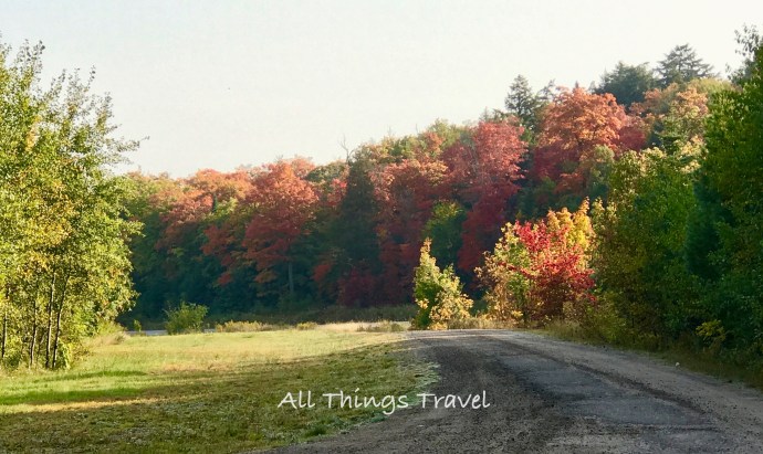
Established in 1893, Algonquin Park is the oldest and most well-known of Canada’s provincial parks. Comprising 7630 square km (2946 sq mi), the park attracts nearly one million visitors each year who come to experience its forests, lakes, and wildlife. We stopped several times for photo opportunities like this.


Canoe Lake


Canoe Lake
When we reached the Algonquin Visitor Center, we had no idea we would spend so much time there. The views were amazing, the exhibits superb, and the wi-fi connection surprisingly good.


Panorama View from Algonquin Visitor Center


Algonquin Visitor Center
I would love to have seen bears, moose, and wolves in the wild but, since we didn’t, these exhibits were a special treat.


A highlight of our visit, the hike to Beaver Pond over rugged terrain was strenuous enough to seem longer than just 2 km but so well-marked we never lost our way.


Beaver Meadow


With 4500 beaver colonies within the park, I was surprised we didn’t see even one of the furry creatures. While we didn’t spot them at work, signs of their presence surrounded us and the result of their labor was impressive.

Beaver dam


Our last stop in the park, the Algonquin Logging Museum consisted of a reception building where we viewed an audiovisual program to introduce us to logging in the park and a trail of less than a mile with 20 outdoor exhibits. At one time, over half of the men in Canada worked in logging camps in the winter. Particularly for farmers, it was an opportunity to earn additional income after harvest, albeit a dangerous occupation.


Camboose shanty where men were housed

Inside the camboose, 52 men slept two to a bunk
Throughout the 1800’s, felled red and white pine were squared using only axes. The notches on the tree below show how deep to cut to square that side of the log. This process was repeated on each side. The result was a log that was easier to stack on a raft for transport and the log was ready to cut into boards at its destination.

To transport the logs to the raft, they had to be loaded onto a sleigh using a jammer, a wooden crane powered by horses.

Jammer
On a steep descent, the sleigh could quickly speed out of control killing the horses in front so sandpipers lined the trail to throw hot sand in the path to slow the sleigh. The invention of the Barrienger brake in the photo below solved this problem

Barrienger brake
Once the logs arrived at the river, the danger was not past. The invention of the log chute assisted loggers in transporting the logs through the water.

Log Chute
This is just a small sample of the information we learned about the history of logging in the area. Logging continues today in over 50% of the park according to scientific guidelines in the Park Management Plan.
As we left the park, I took the photo below. We were delighted to get over 56 mpg (23.8 kpl) regularly on this trip. Traveling at slower speeds on two-lane roads through Canada and using unleaded fuel rather than gasohol each contributed to our excellent gas mileage. Also, note the temperature on September 17 was 82 degrees (28 C).


Successfully escaping Toronto traffic, we headed south for our first look at Lake Ontario, our third of the five Great Lakes and to spend the night in Kingston, Ontario. Rather than taking the freeway at Belleville, we opted to drive along the coast as much as possible.


My paper map showed a bridge at Glenora but Google maps on my phone didn’t show a bridge. I was concerned that we’d end up backtracking but we were delighted to find a ferry when we arrived and it was free. After a short wait, we enjoyed a pleasant crossing to Adolphustown where we continued our drive along the lake to Kingston.

Glenora Ferry Dock

Glenora Ferry

Our Prius on the ferry

Lake Ontario
We asked at our hotel in Kingston for a restaurant recommendation and headed downtown to Dianne’s Fish Shack and Smokehouse. Located near the waterfront, we explored the area a bit before dinner. The AAA Tour Book confirmed Kingston was founded in 1673 as a fur trading post and strategic military base. With a population today just under 130,000, it’s also home to over 24,000 students at Queen’s University. 

Sitting outside at Dianne’s Fish Shack and Smokehouse, we could hardly believe our good fortune to have such a pleasant evening. Jim ordered the pork carnitas and I decided on the seafood poutine. Poutine is a French Canadian classic consisting of french fries, cheese curds, and gravy. Dianne’s seafood poutine, however, was made with fries, coconut green curry, shrimp, haddock, calamari, mussels, and queso fresco. Yum!


After a quick stroll to the water following dinner for another lighthouse photo, we returned to our hotel for the evening.


Kingston, located where Lake Ontario meets the St. Lawrence River, was a good place to begin our drive the next morning to explore the Thousand Islands. Come back to read all about it.
Based on events from September 2017.